

A Spectacular ´Map Theatre´: The 1593 edition of Christiaan Adrichem´s Theatrum Terrae Sanctae
Sacred geography (geographia sacra) was a flourishing field of scholarship in the early modern period. The atlas of the Holy Land by Christiaan van Adrichem falls squarely within this category of sacred geography.
Sacred geography (geographia sacra) was a flourishing field of scholarship in the early modern period. Interest in new scientific or empirical methods for cartography was often combined with a historical-philological method that paid much attention to the study of geography in ancient texts, including the Bible. At the time, knowledge about the geography of biblical events was considered an important accomplishment for any scholar of the Bible.
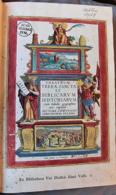
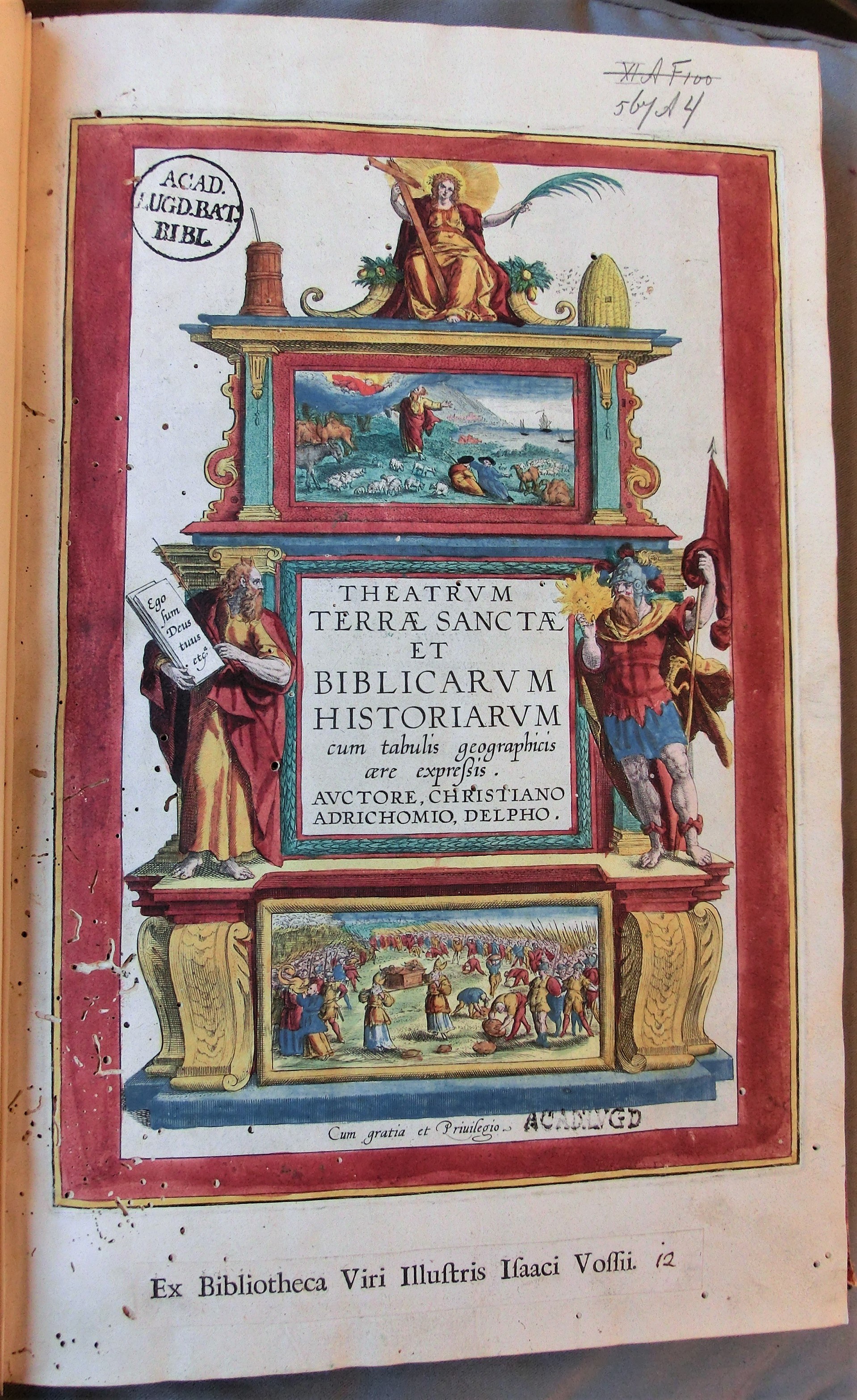
The atlas of the Holy Land by Christiaan van Adrichem falls squarely within this category of sacred geography, as its title testifies: Theatre of the Holy Land, and of biblical histories, expressed with geographical copperplate engravings. The term theatrum is used metaphorically here: it refers to early modern ideas about the organization and communication of knowledge, and it often appears in book titles with this meaning. Adrichem’s Theatrum of the Holy Land thus aims to offer a systematically organized window on the historical geography of the Bible.
The specific copy of Adrichem’s biblical theatre of the Holy Land preserved at UL special collections is of particular interest for two reasons. First, its engravings have been highlighted with bright, vibrant colours that accentuate the detail of these beautiful plates. Second, this particular copy was owned by Isaac Vossius (1618-1689), a well-known Dutch scholar and book collector, famous for his outstanding private library. Vossius’ library included a large collection of maps and atlases, most of which are still preserved in the Leiden collections: some 25 atlases (including Adrichem’s) and around 180 maps. This previous ownership is proudly indicated by a strip of paper that was pasted onto the book’s title page, probably already in the late seventeenth century, stating: 'Ex bibliotheca Viri Illustris Isaac Vossii'.
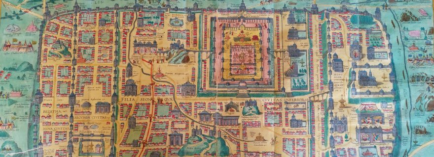
The author of this volume, Christiaan Kruik van Adrichem, was born in the Dutch city of Delft in 1533. He was consecrated as a Catholic priest in his early thirties (also serving as the confessor of the nuns of St Barbara convent in Delft) and authored several works on prayer meditation and biblical scholarship. In the context of the religious upheavals of the Dutch Revolt, Van Adrichem relocated several times within the Low Countries, before finally settling in Cologne. While living there, he turned his attention to studying the geography of the Holy Land, first publishing a geographical description of Jerusalem at the time of Christ in 1584. This book includes a fold-out map, and was reprinted several times (in 1584, 1588, and 1592) after Van Adrichem’s death in 1585. In line with the author’s religious orientation, it is possible to detect a Catholic perspective on the topography of Jerusalem, which foregrounds sacred sites revered by Catholics and meditation on Passion of Christ and his Way of the Cross (via crucis).
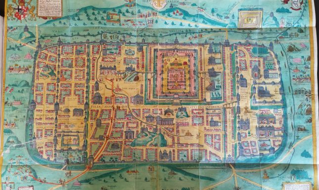
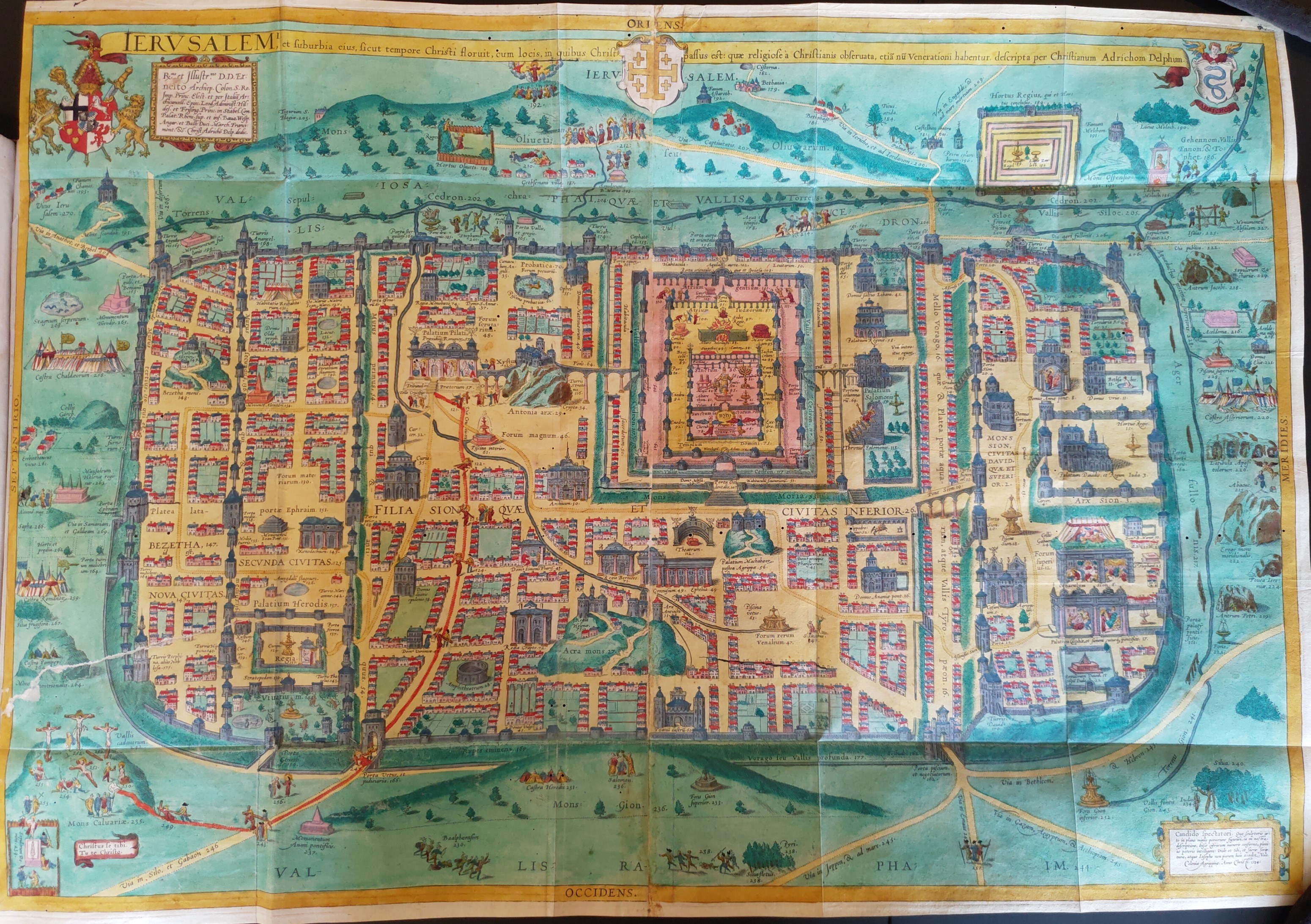
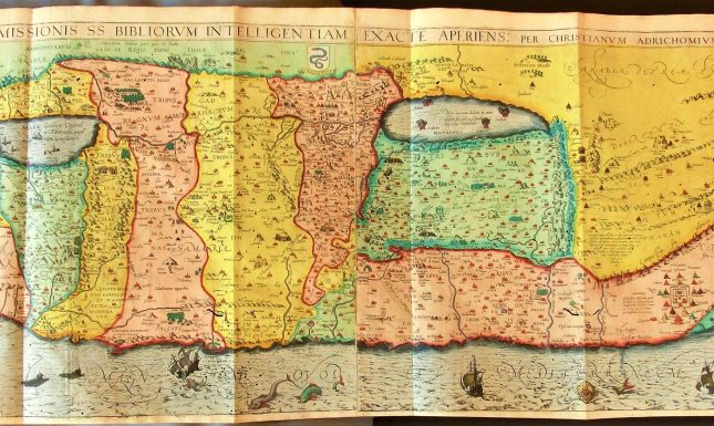
This description and map of Jerusalem were also included in Theatrum Terrae Sanctae, which was first published (posthumously, as a separate book) in 1590 and would be reprinted four times. The copy preserved at Leiden belongs to the second edition of 1593, published by Birckmann in Cologne. The Theatrum consists of the main parts: 1) a description of the Holy Land, 2) a description of Jerusalem, 3) and discussions of the region’s history. As is typical for early modern atlases, Jerusalem and the Holy Land are presented through a combination of textual descriptions and spectacular fold-out maps. For example, the spectacular fold-out map of the Holy Land divided according to the territories - highlighted in different colours - of the twelve tribes of Israel (cf. Old Testament), is accompanied by a substantial discussion in Latin about the tribes and their geographical placement. One can easily imagine how this combination of text and image may have been helpful for scholars eager to better understand the historical geography of the Bible. The popularity of Van Adrichem’s atlas of the Holy Land is testified not only by its several editions but also by its enduring influence on seventeenth-century maps of Jerusalem and the Holy Land, many of which were in some way inspired by the Theatrum.
About the author: Dr. Marianne P. Ritsema van Eck works at the Leiden Institute for History. Her main research and teaching interests centre on religious culture of the late medieval and early modern period, particularly its expressions at the intersection of visual, material, and textual culture.
Further reading:
“Adrichem, Christiaan van,” in Biographisch woordenboek der Nederlanden, edited by A.J. van der Aa, continued by K.J.R. van Harderwijk & G.D.J. Schotel (Haarlem, 1852-1878).
Laor, Eran, and Shoshana Klein. Maps of the Holy Land: Cartobibliography of Printed Maps, 1475-1900 (New York: Liss, 1986).
Münch, Birgit Ulrike. “Körper und Karte. Historizität, Topographie und Vermessung medialer Wissensräume der Passion in der Frühen Neuzeit bei Christiaan van Adrichem und anderen,” in Räume der Passion. Raumvisionen, Erinnerungsorte und Topographien des Leidens Christi in Mittelalter und Früher Neuzeit, edited by Hans Aurenhammer und Daniela Bohde (Peter Lang, 2015), 49-79.
Rubin, Rehav. Image and Reality: Jerusalem in Maps and Views (Jerusalem: Magnes, 1999).
Shalev, Zur. “Early Modern geographia sacra in the Context of Early Modern Scholarship,” in The Oxford Handbook of the Bible in Early Modern England, c. 1530-1700, edited by Kevin Killeen, Helen Smith, and Rachel Willie (Oxford University Press, 2015). DOI: 10.1093/oxfordhb/9780199686971.013.12
Vries, Dirk de, “Atlases and maps from the library of Isaac Vossius (1618-1689),” International Yearbook of Cartography 21 (1981): 171-94.